
Creation of the Manhattan Structure (1811)
1811 - The Commissioners Plan of 1811
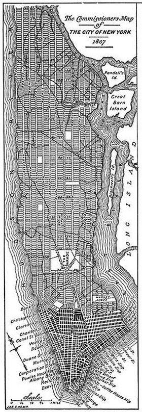
By 1800, the population of New York was 60,000 and in just 10 year the population jumped to 90,000 people (Gladding 2004, p 37). New York was officially the largest American port and city thanks to the creation of the Erie Canal, various European wars and the founding of the Stock Exchange in 1792 (Gladding 2004). In the 1780’s commerce started to take over New York’s city streets. Private houses started to spring up amidst businesses around Battery and Broadway. New York needed to create a development plan, and in 1811 the Commissioners’ Plan headed by Governor Morris, Simeon De Witt and John Rutherfurd, helped establish the Manhattan grid.
This plan took into account the entire 13 miles running up and down Manhattan, not just the already developed 2 mile stretch (Gladding 2004). From 8th to 14th street the land was broken up into the recognizable rectangular blocks, each measuring 200 by 800 feet, then divided into 50-70 lots (Gladding 2004, p 44). There were 12 vertical avenues and 152 horizontal streets. The creation of the Manhattan street grid in 1811 changed how New York would grow, expand, and develop. This act (and its enforcement) is completely responsible for the street grid we see today.
