
Regional Planning (1929)
1929- NY Metropolitan regional planning calls for centralized reforms for the whole metropolitan area on a large scale
Between 1910 and 1928 authorities saw the need to control the development outside of the downtown area due to the increasing popularity on the automobile (Johnson 1996). While the plan was published between the wars, it reflects ideals from the progressive area of planning.
In the late 1800’s and the start of the 20th century 3 transportation changes greatly affected the layout f New York; the railroad, street railways, and elevated rapid transit in the downtown area (Johnson 1996). Population growth and decentralization became concerning factors for the metropolitan authority. By the end of WWI highway systems were only facilitating this spread further. The overall population of New York City was spreading north towards the other boroughs (away from Manhattan), and plans needed to be made to accommodate these new residents (Johnson 1996).
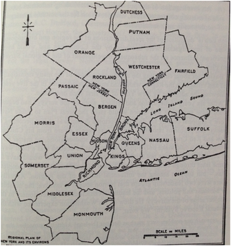
In 1903 Mayor Low created the New York City Improvement Commission which picked up Olmsted’s beautification of the city. Following this example, Brooklyn attempted to create their own comprehensive borough plan 7 years later, and Newark NJ followed shortly after that. While neighborhood planning grew in popularity, so did zoning regulations. The Metropolitan Authority saw how each location was being pulled in different directions and decided to join forces and create the Regional Plan of New York in 1929. On the surface the plan involved economic base theory and population projections to forecast/decide future development patterns (Johnson 1996). These projections then impacted the development of highways, parks, and open space. The total area of the Metropolitan region included parts of Connecticut, New York State, Northern New Jersey, and Long Island.
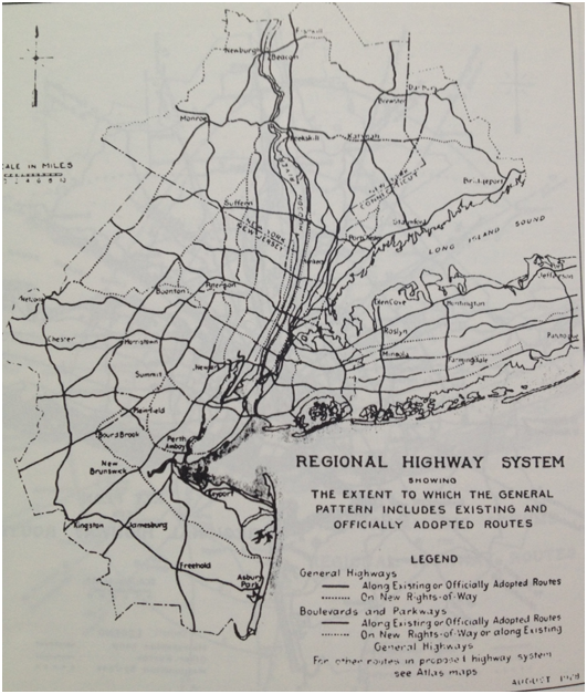
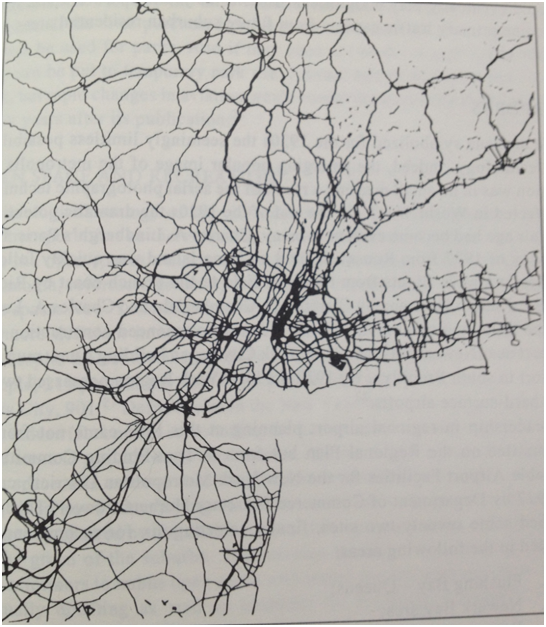
The target year for the plan was 1965, but WWII cut it short by about 20 years (Johnson 1996). One major criticism of the regional plan was the definition of “comprehensive” for the plan was somewhat small (Johnson 1996). The plan really only focused on transportation and recreation. Several decades after the Regional Plan was created, it was abandoned for newer measures. This plan, while not entirely successful, did help lay down developments patters and highway systems to connect the overall tri-state area. The picture on the left is what the planners envisioned for the highway system. The right is what was actually constructed by 1965.
In the late 1800’s and the start of the 20th century 3 transportation changes greatly affected the layout f New York; the railroad, street railways, and elevated rapid transit in the downtown area (Johnson 1996). Population growth and decentralization became concerning factors for the metropolitan authority. By the end of WWI highway systems were only facilitating this spread further. The overall population of New York City was spreading north towards the other boroughs (away from Manhattan), and plans needed to be made to accommodate these new residents (Johnson 1996).
In 1903 Mayor Low created the New York City Improvement Commission which picked up Olmsted’s beautification of the city. Following this example, Brooklyn attempted to create their own comprehensive borough plan 7 years later, and Newark NJ followed shortly after that. While neighborhood planning grew in popularity, so did zoning regulations. The Metropolitan Authority saw how each location was being pulled in different directions and decided to join forces and create the Regional Plan of New York in 1929. On the surface the plan involved economic base theory and population projections to forecast/decide future development patterns (Johnson 1996). These projections then impacted the development of highways, parks, and open space. The total area of the Metropolitan region included parts of Connecticut, New York State, Northern New Jersey, and Long Island.
The target year for the plan was 1965, but WWII cut it short by about 20 years (Johnson 1996). One major criticism of the regional plan was the definition of “comprehensive” for the plan was somewhat small (Johnson 1996). The plan really only focused on transportation and recreation. Several decades after the Regional Plan was created, it was abandoned for newer measures. This plan, while not entirely successful, did help lay down developments patters and highway systems to connect the overall tri-state area. The picture on the left is what the planners envisioned for the highway system. The right is what was actually constructed by 1965.
|
|
